Sunday, October 30, 2011

Antelope Island - White Rock Loop Trail

Hike: Antelope Island - White Rock Loop Trail
Elevation Gain:  700 feet
Time: 4.5 hours
Distance: About 7 miles
Overall Impression:  This was very different from the hikes we've been doing in the mountains!  It was like one big yellow-grassy meadow with the occasional bison to keep us on our toes.  The views of the Great Salt Lake were mystical and hazy, the path was pretty easy, and we had a great time!

This was our first time driving North of Salt Lake City, unless you count that time we accidentally went North for a mile or two while driving ourselves to the airport.  Woopsies!


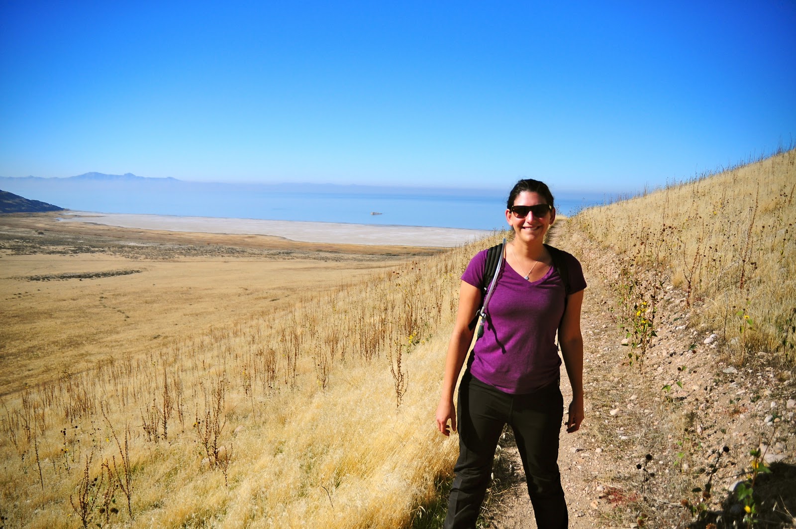
So first of all, don't make the same mistake we (Steve!) did.  After you park your car in the day-use lot, be sure to go left immediately  after passing through the fence.  You will then be on the right track and won't have to go off the trail and up the mountain-side to get back on the trail like we did, and like Steve is seen doing below.


It was a sunny, "last weekend of October" day, and though we expected it to be chilly, it was warm enough to shed almost all our layers!  I didn't post the picture of Steve airing himself out at one point.  (Luckily there were no people around really.)

They had spent the last two days rounding up the bison to do some tagging/checking/medicating stuff that they do every Fall and the ranger at the visitor's center told us that only the bulls who refused to be rounded up were still roaming the hills of the island.  I was hopeful we would see some, but a little weary of how aggressive these bulls might be.

Here I am, getting sun burned in almost-November!  Remember a hat and sunscreen, people!


We walked along enjoying the unique scenery and soon came upon our first bison herd.  Cool!  We haven't seen much wildlife yet here in Utah so this was pretty exciting.  We didn't get too close, but we did walk a bit towards them and then got scared when one or two stepped forward from the herd and looked right at us.  Ahh!  Steve suggested we climb up some rocks if the bison charged toward us.


When we actually got close to that rock, I realized it wasn't exactly a safe haven.  But it was a nice place to sit for a moment.


We took a side trip up Beacon Knob where there are a couple of picnic tables, and enjoyed our now go-to hike lunch of an Einstein Bros bagel with "schmear."  Delicious.

As we neared the end of the hike, we came across a few more bison, this time closer to the trail.  I must admit I was pretty nervous as we passed this guy by.  He stared us down every step of the way, but didn't make a move.  I don't know what I would have done if he had charged.


It's funny, I often have this peaceful, innocent feeling while we're hiking along like two clueless idiots in a horror movie, totally unaware of the spooky background music and impending danger.  You know those scenes, like of children playing in the lake and then they show their legs dangling and kicking playfully from the viewpoint of something scary lurking below?  Nothing has happened to us by any means, but I just feel pretty naive in the wilderness and like I'd have no idea what to do if something were to happen.  Hmm.. maybe I should do something about that feeling.


This bison was literally standing ON THE TRAIL as we got closer to the end of the loop.  We decided to walk through the long grasses a few feet away from him instead of risking any close encounters.

In the end, the bison were the highlight of our hike!  Nothing like a little bit of threatening wildlife to add some spice to an otherwise pretty but kind of monotonous hike.  Steve would disagree about my assessment of "monotonous".  He remarked upon its beauty at least once every ten minutes.  Might I remind you we hiked for 4.5  hours.

It was definitely a nice change, but I prefer the mountain hikes.

Sunday, October 16, 2011

Millcreek Canyon - Alexander Basin

Hike:  Millcreek Canyon - Alexander Basin
Elevation Gain:  A LOT
Time:  We didn't go the whole way, so I don't know.  We took about 3 hours or so.
Distance:  Again I don't know, but probably about 4 or 5 miles
Overall Impression:  This was DIFFICULT.  It was a steep ass mo'fo, especially at the beginning for the first mile or so.  But beautiful.

I don't know what was wrong with me today but I felt tired and out of shape.  So it was kind of frustrating to be struggling while out hiking with our friends/Steve's colleague and his wife who are super fit!  They were cool, though, and eventually I felt better, especially after the initial climb.  Wow, this was steep!  I didn't take any pictures of the steepest part, but this picture below will kind of give you an idea.


The views really paid off.  It had snowed in early October up in the mountains so there was still some evidence of that dump.  We didn't have to walk through any snow, luckily, and it wasn't too cold either.


The views were stunning!  We could see the reds in the lower mountains below us, and the yellows surrounding us.  I don't know the names of the trees yet but our friends knew and told us all about it.  I forget everything I learned.  I'm a bad source of information.  All I can tell you is that it was so pretty!  Look below for evidence!


We brought Einstein's Brother's bagels up the mountain with us for lunch.  Bagels are the one thing I've been missing from home.  Bagels and bread.  Why is the bread in grocery stores here so NOT delicious?  I don't get it.  I've been disappointed almost every single time.  We bought a couple of delicious loaves from the Farmers' Market but that's pretty much done now.  Anyway, Einstein's was quite good actually, despite the fact that it's a chain, and we'll probably be visiting it regularly to fulfill our bagel-loving ways, at least until we find a better alternative.

It was beautiful.  I love the Wasatch in the Fall!  Watch out for that first mile or so - it's a doozy!

Sunday, October 9, 2011

Fifth Water Springs

Hike: Fifth Water Springs
Distance: Around 3 miles
Elevation Gain:  About 1000 feet
Time:  Around an hour
Overall Impression:  Fun, but too busy and kind of dirty.

This Sunday after meeting at the Park Cafe for way too much delicious bacon, we went with two other couples to check out the hot springs at the Fifth Water Springs near Diamond Fork, Utah.  This was in and around the Provo area, about an hour-ish away from Salt Lake.  Sorry about my lack of precision...

We set off and walked through the beautiful Fall scenery along the babbling brooke.  There were lots of friendly people around, walking their cute dogs and making us jealous that they have furry friends to take along with them.  Steve and I aren't ready for the commitment yet, but we can dream.

 This is Steve leaving the parking lot.  We always look way dorkier than anyone else out hiking, but I like the way he looks here.  Way to nail it, babe!

This is the view of the stream we hiked along.  The hot springs feed into this water.


As we made our way closer to the hot springs, it started to smell like sulpher.


Mid-October hiking in the Wasatch is wonderfully beautiful, in case you didn't know.  I was an East Coast snob, thinking our colors were prettier than these Western states, but no.  Utah's got it going on.


I didn't really take any pictures of us in the hot springs, but this is the picture of us standing around trying to figure out how to change and get into the hot spring.  It was busy with people, kind of dirty, with trash laying around here and there, and lots of dirt floating in the water.  And we were a little disappointed by the man-made feeling of the springs themselves.  I'm not sure exactly how much intervention there has been to provide the public with this hot spring service, but there are pipes and what looks like cement in and around the springs.  We didn't love that.  Plus, the water could have stood to be hotter, in my opinion.  I mean, if you're going to run a pipe, why not put in a heater? ;)


It was tough and cold and muddy to change back into my clothes afterwards too.  Wah, wah, wah.

Then we hiked up higher to find a place for lunch.  Some of us attempted this death defying stunt.  I took the long way around.  Later, I slipped in some wet mud while trying to climb up a bank and bruised and scratched my elbow.  Steve worried about the camera in my hands instead of whether or not I was hurt.  The nerve!

We found a very pretty spot to sit and eat our sandwiches and cup o'soup that we brought along, and enjoyed chatting with our new friends and getting to know each other.  Gotta love other transplants all here in similar situations as us.  :)


We walked back down the hill, chatting away still.  At the end of the hike as we stood in the parking lot saying our goodbyes, one guy found this preying mantis.  Pretty striking, isn't it?


Sunday, October 2, 2011

Lofty Lake Loop / Our First Backpacking Trip

Distance: Only about 4 miles in total
Elevation Gain: 916
Highest Peak: Almost 11,000 feet!
Time: 3 to 4 hours, though we slept over in between!
General Impression:  This was very high altitude, and while there were some steep parts, it was beautiful, relatively quiet, and fun!
Difficulty: Intermediate

We went on this trip with some new friends we've met and started getting to know.  He encouraged us to try our first ever backpacking trip!  We chose something that would be beautiful, that had water we could filter, and that was not too long so we could ease in to the idea of carrying all our stuff.

This is a beautiful loop hike in the high Uinta's.  In fact, Lofty Lake's claim to fame is that it's the highest altitude lake in all of Utah.  Wow!  We hiked up heading clockwise from the parking lot and it was never really all that steep.  After just an hour or more we stopped at Kamas Lake where we decided we would camp for the night.  We would hike up and then down the other side of the loop the following day.  We may have seen a handful of other hikers, and definitely no other backpackers, but that was probably because the forecast was for rain.

After setting up camp in a grassy field across the trail from the lake, we headed down to the water to pump, and to snack on the delicious guacamole and tortilla chips our friends had brought.  Great snacks = happy campers.


They were easily able to get a strong fire going, despite the wet ground and the light showers that kept us on our toes off and on throughout the afternoon.  Steve and I felt a bit incompetent after our recent camping trip where we tried and tried and tried to get a fire going to no avail.  These guys did it with no trouble at all!!!

Before dinner we headed out on a walk around Kamas Lake.  Don't be fooled by it's pretty banks along the trail.  The back side of the lake consisted of a pile of boulders that we had fun traversing and trying hard not to fall into the water.


After that walk, which took a bit longer than anticipated (photo pops take time, too!), we headed back to our fire pit, which was already set up by some previous campers) and we made ourselves some dinner.  We brought Tasty Bites and powdered potatoes and it was the best camping food ever.  Easy, quick, and delicious, and not all that terrible for you.  Mmm mmm.  We hung out by the fire and soon enough it was time to throw our food up into a tree and head to sleep.  Again, thank goodness for our friends because we know nothing about anything to do with camping.

Note that our camp was set up well above 10,000 feet.  Steve felt nauseous and sometimes lightheaded and dizzy, and we both felt like we couldn't catch our breath as we lay in our sleeping bags about to fall asleep.  Steve woke me up a couple of hours into the night complaining that he felt like he might vomit, so we got out of the tent and nothing happened.  Luckily he was never sick.  He thought it might have been the Tasty Bites, which bummed me out because I was excited about finding such a good and easy camping meal option.  When we got home and looked a little more into altitude sickness, we realized that this must have been what he was feeling.  At over 10,000 feet you can start to feel a little yucky!

The next day we took our time getting up and moving, but eventually set out to head up to Lofty Lake.  Along the way were some beautiful vistas of the mountain range below.


Lofty Lake was pretty, but nothing special really.  There were more hikers on Sunday, and a bunch with dogs.  Some people were coming up to fish.  We pleasantly walked along, heading mostly downhill on this day.  It was really, really lovely.

We enjoyed this hike a lot and thought it would be a good one to do with our relatively fit friends who hopefully will one day come and visit us.  :)

Monday, September 26, 2011

Alpine Loop and Cascade Springs Interpretive Trail


Distance: Very short (probably around 1 mile)
Elevation Gain: None, although there were a couple of short, steep walks, and a bridge or two were quite curvy.  :)
Highest Peak: N/A
Time: About 45 minutes if you walk around the whole place
General Impression:  It was very pretty, but very crowded and not much of a hike really.  I would go back with older relatives or younger children, but I wouldn't rush back again just for myself.

On Thursday of last week we decided to check out a free Boot-camp provided by LuluLemon at 9th and 9th.  And it KILLED us.  I mean, it was literally painful to move in any way, shape, or form for days afterward.  I can't begin to count how many burpees the instructor made us do, but it was 10 times more burpees than I've ever done before.  Steve basically did die for about an hour after the class, but luckily he came back to life after eating some Thai salad rolls and soup.

So on Sunday, our usual hiking day, we were a bit weary of taking on a big, multi-hour hike.  We also wanted to check out some more Fall colors, and a friend recommended Alpine Loop.  This is technically a drive, not a hike.  And WHAT A DRIVE IT IS!

We paid $6.00 at the entry to the canyon/park place as we were planning to stop.  If you plan to drive right through, you don't need to pay.  Then we stopped at the visitors center to empty our bladders and check out the info.  There were lots of kids everywhere.  Kids, kids, kids.

Driving on from there, we headed up into the mountains and passed more and more beautiful views of mountains, trees, and colorful leaves.  It was amazing.  And our Phish soundtrack didn't hurt.  We got out a few times to take pictures, which I'll let speak for themselves.

Along the drive, we took a little detour to stop and check out the Cascade Springs, which are some naturally forming pools with sediment or something/I'll let Steve explain this one a bit better.  They have built a very accessible boardwalk and path in and around the springs, consisting of three short loops you could walk around for a total of 45 minutes, so this is what I'll consider our "hike" for the purposes of this hiking Utah blog.  There were again lots of kids and families and flip flops here, so remember this one for visiting family or when we have babies or something.  But it was very beautiful and a nice, easy walk in nature.  We felt lucky, again, to be living in Utah.

There was no real elevation gain to speak of, and it's really the easiest walk ever, but it's pretty! 


Wasatch Mountains: Wilson Peak (near the towns of Midway and Weber)

Distance: 7 or 8 miles (we really need to start using the Garmin for hiking)
Elevation Gain: About 1,200 ft
Highest Peak: 8,497 ft
Time: About four hours including some time for lunch and to put moleskin on a blister.
General Impression: BEST HIKE SO FAR!  That might not say much, but this hike had the most impressively beautiful view of the Wasatch and Unita mountain ranges and the valleys below.  The fall colors are out in near-abundance and we LOVED IT!


The volunteer at the Wasatch Mountain State Park Visitor's Center told us to just drive up the road a little while until we passed a big hairpin turn to the left, and then a smaller but still noticeable turn to the right.  Soon after these two turns we would come to a clearing on our right with a path and a culvert.  We found all of these things with no problem, though we were a bit worried we'd miss it as there are no signs whatsoever.  The guy was right, though, and the turns are "hairpinny" enough that you'll know it when you see it.


We set off on our hike at 10:30 in the morning, heading up, up, up a path/road that showed signs of car tracks here and there.  Early on in the hike we passed two small water obstacles, but it had just rained the night before, so don't expect these all the time.  Also, there were banks or rocks to step on and avoid submerging our feet in any water, so we high-fived and pressed on.

The trail was pretty steep, with long switchbacks that sometimes felt never-ending but were never too too bad.  The benefit is that we were often rewarded with stunning views of the colourful valley below.  We could see our car getting smaller and smaller and we climbed higher and higher.  There were lovely wild flowers all around, and lots of trees.  

Once we reached the top, which took I have no idea how long, we headed along the rim trail (I think that's what they call it), which consisted of tall yellow grasses and very few trees.  We could see over to the other valley below, so the view was simply astounding. 

Steve was stung or bitten by an insect at one point.  Although it was pretty painful, he was fine and he pressed on. It didn't really look like anything, but by the next morning his wrist had swelled up about an inch more than it's normal size and was itchy, hot, and painful.  Poor guy.

I felt like I had a small stone in my shoe so I stopped to shake it out, but nothing really fell out.  While I love the feeling of my Asolo's, I do find that they need emptying now and then during a hike which can be rather annoying.  I hiked up towards Steve, who had gotten ahead of me, feeling tired and pissed off that the feeling of the rock still hadn't gone away.  When I reached him, we looked again and found an angry blister had appeared on my heel.  Steve patched me up with some Moleskin from our first aid kit and we pressed on.

Soon the landscape changed from grasses to forest.  The trees were lovely birches I think, though my tree-knowledge is really lacking.  

After about two and a half hours we reached the top.  There we found a little building with all kinds of radio antennae or something sticking out of it.  I'm not exactly sure what they were.  We found a spot with a view (what a view!) and sat and ate our salami, bread, and artisan cheese.  It was delicious and peaceful and swell.

The walk down felt kind of long but not too bad I guess.  We often feel ready to be done about an hour or so before we actually are.  I'd really like to do a hike that was not an out-and-back to see what it feels like.

The total hike took about 4 hours and was very beautiful!  Thank you Mt. Wilson, or whatever your name is!

Sunday, September 18, 2011

Wasatch Mountain State Park: Visitor's Center and Spring Pond Loop

Distance:  Approximately 2 miles
Elevation Gain: Not that much.  We need an altimeter.
Time:  About an hour and a half
General Impression:  Beautiful!  This was easy and nice for a short afternoon hike.

This weekend we decided at about 10:00AM on Saturday morning that we were going camping for the night.  We didn't actually arrive at Wasatch Mountain State Park until probably around 2:00PM or something like that, and after setting up our tent and everything, we didn't have all that much time left before it would start getting dark.  We decided to do a quick hike while we still had the time.  Right across from the visitor's center are a few well-marked trails that we walked along for about an hour and a half.  We started on what they call the Visitor's Loop and then took a small detour around the Spring Pond loop.


It was lovely.  The colors have started to turn and every now and then we were greeted with a splash of red or yellow.  We walked along a well-maintained but narrow dirt/mud path with tall grasses tickling our legs.  And of course, we were very impressed with the mountain views.

I had my DSLR camera with me, which I haven't taken hiking until now.  It was nice to have it and be able to take beautiful pictures, but it slowed me down and I think Steve got a bit impatient with me.  We certainly got some beautiful pictures, though!  Overall it was a very pretty and easy hike that I would definitely recommend if you're in the area!  Apparently you can also do some apple picking which could be fun.  We didn't see anyone else on the trail, by the way.


Sunday, September 4, 2011

The High Uintas: Grandaddy Lake

Distance: 7 miles
Elevation Gain: About 1000 feet
Highest Point: 10,640 ft at Hades Pass
Time: About five hours
General Impression: So beautiful!  It was quiet, the scenery was incredible with grassy meadows, rocky trails, lovely trees and flowers, and pretty streams and views of the lakes in the area.  A true gem!

All I can say about this one is WOW.  Not only was the trail beautiful, but we felt great.  We didn't tire and need to stop nearly as much as we did on our Lake Mary hike.  So either we're slowly getting more fit, or we're slowly getting more used to the high altitude, or there's something else going on.  Anyway, we both were feeling great and we loved every bit of this hike.

We had a later start than we intended (cooking and cleaning up breakfast at our Hades campsite took longer than we planned) and only got to the trailhead at around noon.  Knowing we wanted to be back at our campsite well before dark, we had kind of a tight timeline on this hike.  We set off, walking along the rocky trail (really, it was quite rocky) and feeling absolutely alone in this beautiful landscape.  There was a small babbling brooke near the beginning of the trail and after that we didn't see any more water again until we reached Hades Pass and caught a view of the lakes.


 We passed a few backpackers, making their way back down after an overnight stay, and exchanged very friendly hellos with them all.  There were a couple of brave families with little children, but really not too many as the trail is not so easy to traverse.


It felt like we reached Hades Pass in no time, and then it took maybe another 45 minutes to get to Grandaddy Lake.  We noticed campers and fishers set up all around the lake, but it was large and peaceful and we were able to find a couple of rocks to sit on to eat our picnic lunch of bread, cheese, and salami.  I pumped us two bottles full of lake water and then we basically had to turn around and head back down immediately so as to avoid being too late on the mountain.  


The hike down felt equally easy and fun, though we were both ready for it to be over and done with by the time we reached the car.  It took about 5 hours, with pretty limited stopping, so I'd say this was our longest hike to date!  We were really happy and excited about how good it felt and how pretty it was.

We give this hike four thumbs up!